Western Regional Climate Center
Alaska Climatology Dashboard
About The Data
Monthly climatologies from dynamically downscaled ERA-interim data.
Global climate model (GCM) and reanalysis data are often too coarse (i.e., >100km) to resolve local climate features (i.e. <<100km) that are influenced by steep gradients around topography and coastlines. In data-sparse regions of Alaska there is great reliance on gridded climate products due to lack of weather stations to assess climate variability and change. ERA-Interim reanalysis data were dynamically downscaled to 20km spatial and hourly temporal resolution using the Weather Research and Forecasting (WRF; Skamarock et al., 2008) model to help address this need across all Alaska. The downscaling domain covers the entire Alaska region including adjacent waters (see Figure 1a, Bieniek et al., 2016) through a project funded by the USGS Alaska Climate Adaptation Science Center. The ERA-Interim reanalysis was downscaled for 1979-2015 and was downscaled because it is one of the best performing reanalysis tested over the Alaska region (Lader et al., 2016). The dynamical downscaling simulations provide winds, temperature, and precipitation as well as all elements of the radiation balance and upper-air atmospheric variables on an hourly temporal scale that is suitable for examining climate variability, trends and extremes in complex topography (Bieniek et al. 2016).
References:
Bieniek, P. A., Bhatt, U. S., Walsh, J. E., Rupp, T. S., Zhang, J.,
Krieger, J. R., and Lader, R. 2016: Dynamical downscaling of
ERA-Interim temperature and precipitation for Alaska. Journal of
Applied Meteorology and Climatology, 55(3), 635-654.
Lader, R., U. S. Bhatt, J. E. Walsh, T. S. Rupp, and P. A. Bieniek,
2016: 2-m temperature and precipitation from atmospheric reanalysis
evaluated for Alaska. J Appl Meteor Climatol, 55, 901-922.
Skamarock, W. C. and Coauthors, 2008: A Description of the Advanced
Research WRF Version 3. NCAR Tech Note, NCAR/TN–475+STR,
113 pp.
Click on the thumbnails below to view or download larger images. An option for metric units is provided in the image display window.
Maximum Temperature, 1981-2010 Average

January

February

March

April

May

June

July

August

September

October

November

December
Minimum Temperature, 1981-2010 Average

January

February

March

April

May

June

July

August

September

October

November

December
Average Temperature, 1981-2010 Average

January

February

March

April

May

June

July

August

September

October

November

December
Precipitation, 1981-2010 Average

January

February

March

April

May

June

July

August

September

October

November

December
10 m Wind Speed, 1981-2010 Average

January

February

March

April

May

June

July

August

September

October

November

December
Snow Water Equivalent, 1981-2010 Median

January

February

March

April

May

June

July

August

September

October

November

December
Snow Water Equivalent, 1981-2010 Average

January

February

March

April

May

June

July

August

September

October

November

December
Snow Water Equivalent, 10th Percentile, 1981-2010

January

February

March

April

May

June

July

August

September

October

November

December
Snow Water Equivalent, 90th Percentile, 1981-2010

January

February

March

April

May

June

July

August

September

October

November

December
About The Data
Aviation flight rules depend on a combination of cloud ceiling height and visibility and dictate the procedures used by pilots when operating aircraft. Establishing a climatological baseline of the frequency of these conditions is necessary in Alaska to bound operational aviation forecasts at airports and are especially critical since a significant portion of transportation in Alaska depends on aviation. Four aviation categories have been established by the Federal Aviation Administration and are Visual Flight Rules (VFR), Marginal VFR (MVFR), Instrument Flight Rules (IFR), and Limited IFR (LIFR). For this analysis hourly ceiling and visibility information were obtained from Alaska automated airport weather observations archived at Iowa State University's Iowa Environmental Mesonet over 1996-2017. The frequency of occurrence of each category was then recorded at key airports throughout Alaska. The aviation frequencies were subdivided by season (JFM, AMJ, JAS, OND) and 3-hr period of the day. Conditional frequencies were also computed by the wind direction at the time of occurrence.
Click on the thumbnails below to view or download larger images.
Bethel Airport (PABE)

Annual

JFM

AMJ

JAS

OND
Barrow/Post-Rogers (PABR)

Annual

JFM

AMJ

JAS

OND
Bettles Field (PABT)

Annual

JFM

AMJ

JAS

OND
Cold Bay Airport (PACD)

Annual

JFM

AMJ

JAS

OND
Cordova/Mile 13 (PACV)

Annual

JFM

AMJ

JAS

OND
Kodiak (PADQ)

Annual

JFM

AMJ

JAS

OND
Dutch Harbor (PADU)

Annual

JFM

AMJ

JAS

OND
Eagle Airport (PAEG)

Annual

JFM

AMJ

JAS

OND
Kenai Municipal (PAEN)

Annual

JFM

AMJ

JAS

OND
Fairbanks International (PAFA)

Annual

JFM

AMJ

JAS

OND
Gulkana Airport (PAGK)

Annual

JFM

AMJ

JAS

OND
Gustavus (PAGS)

Annual

JFM

AMJ

JAS

OND
Skagway (PAGY)

Annual

JFM

AMJ

JAS

OND
Haines (PAHN)

Annual

JFM

AMJ

JAS

OND
Homer (PAHO)

Annual

JFM

AMJ

JAS

OND
Juneau International (PAJN)

Annual

JFM

AMJ

JAS

OND
King Salmon (PAKN)

Annual

JFM

AMJ

JAS

OND
Ketchikan International (PAKT)

Annual

JFM

AMJ

JAS

OND
Kaltag Airport (PAKV)

Annual

JFM

AMJ

JAS

OND
Merrill Field (PAMR)

Annual

JFM

AMJ

JAS

OND
Anchorage International (PANC)

Annual

JFM

AMJ

JAS

OND
Nenana/Muncipical (PANN)

Annual

JFM

AMJ

JAS

OND
Nome (PAOM)

Annual

JFM

AMJ

JAS

OND
Northway (PAOR)

Annual

JFM

AMJ

JAS

OND
Kotzebue/Ralph Wien (PAOT)

Annual

JFM

AMJ

JAS

OND
Petersburg (PAPG)

Annual

JFM

AMJ

JAS

OND
Nuiqsut (PAQT)

Annual

JFM

AMJ

JAS

OND
Deadhorse (PASC)

Annual

JFM

AMJ

JAS

OND
Sitka/Japonski Airport (PASI)

Annual

JFM

AMJ

JAS

OND
Saint Paul Island (PASN)

Annual

JFM

AMJ

JAS

OND
Tanana/Calhoun Memorial (PATA)

Annual

JFM

AMJ

JAS

OND
Talkeetna (PATK)

Annual

JFM

AMJ

JAS

OND
Portage Glacier Center (PATO)

Annual

JFM

AMJ

JAS

OND
Wrangell (PAWG)

Annual

JFM

AMJ

JAS

OND
Wainwright Airport (PAWI)

Annual

JFM

AMJ

JAS

OND
Yakutat (PAYA)

Annual

JFM

AMJ

JAS

OND
Winds at Alaska Airports
SNAP/WRCC Historical Wind Visualization Tool
About The Data
Snow cover has important links to hydrology, ecology and transportation in Alaska. The amount water in the snow pack, snow water equivalent (SWE), describes not only the quantity or density of snow on the ground, but the amount of liquid water that will be available for runoff after the spring melt. The end-of-season SWE (EOS-SWE) integrates much of the snowfall through the winter and is a critical indicator of the water available once the melt begins. In this analysis 618 stations with data spanning 1979-2014 were obtained from the IMIQ database for Alaska. The stations included National Weather Service observations at airports, SNOTEL, NRCS snow courses and research sites. The yearly EOS-SWE for each station was determined for three separate dates by selecting the amount SWE on or nearest March 1, April 1 and May 1. The search period for stations without data on the EOS-SWE date was limited to no earlier than the 20th of the previous month or the 20th of the current month. Climatologies were computed for each station with at least 10 years of data, which was used to compute percent of normal EOS-SWE at the corresponding stations for each year.
Click on the thumbnails below to view or download larger images.
End-of-Season SWE Averages in Millimeters

Season Ending March 1

Season Ending April 1

Season Ending May 1
End-of-Season SWE by Year in Millimeters
Season Ending March 1
Season Ending April 1
Season Ending May 1
End-of-Season SWE by Year as Percentage

Season Ending March 1

Season Ending April 1

Season Ending May 1
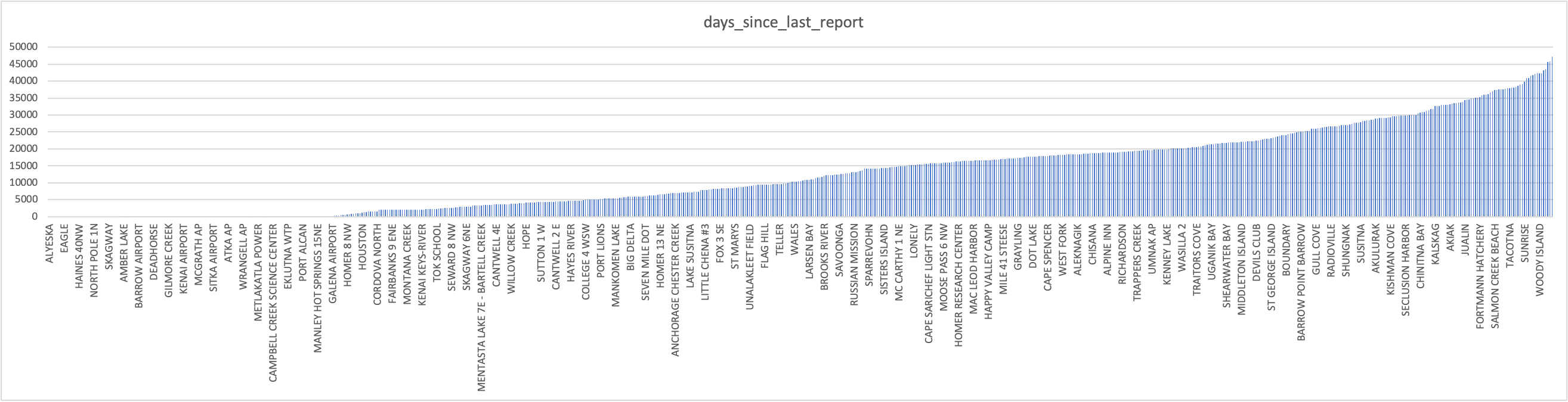
Alaska's COOP Network Over Time
NOAA's National Weather Service Cooperative Observer (COOP) Network in Alaska has changed over time. These are manual measurements taken by private individuals or sometimes employees at a local utility or other business. Most paid observer programs within NOAA have transitioned to voluntary ones. This has generally led to a decline in observations with time. Here is more information about NOAA's COOP network.
See below for a time series of observations from Alaska's COOP network, as well as an animation of COOP spatial coverage by decade.
credit: WRCC and NCEI Regional Climate Services
credit: WRCC