Western Regional Climate Center
January in the West
January, 2019
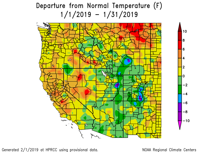
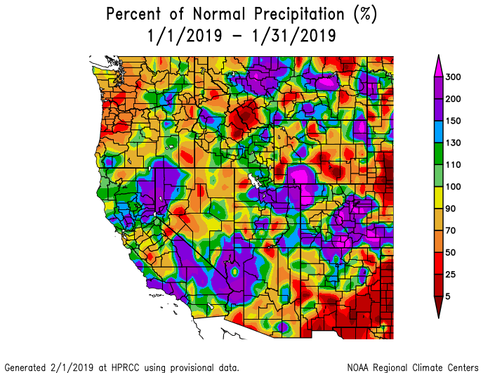
Active weather throughout January brought above normal precipitation to the Southwest and some Inland Northwest locations. The Pacific Northwest observed below normal precipitation. January temperatures were above normal in eastern Montana, portions of central and northern California, Nevada, and the Pacific Northwest. Slightly below normal temperatures were observed across the Rocky Mountains.
Several areas of the Northwest observed well above normal temperatures. In northeastern Montana, Glasgow reported an average temperature of 22.2 °F (-5.4 °C), 8.4 °F (4.7 °C) above normal and the 8th warmest January since records began in 1948. In eastern Oregon, Baker City reported an average temperature of 31.6 °F (-0.2 °C), 6.5 °F (3.6 °C) above normal and the 11th warmest January since records began in 1943. California and Nevada also observed above normal temperatures. Battle Mountain, Nevada, recorded 38.1 °F (3.4 °C), 7.2 °F (4 °C) above normal and the 5th warmest in a 76-year record. In central California, Fresno reported 52.5 °F (11.4 °C) 5.9 °F (3.3 °C) above normal and the 4th warmest January since records began in 1949. Below normal temperatures were recorded in a broad swath from western Wyoming to southern Arizona. Lander, Wyoming reported an average temperature of 17.7 °F (-7.9 °C), 4 °F (2.2 °C) below normal. In southeastern Utah, Bluff observed an average temperature of 28.6 °F (-1.9 °C), 3.7 °F (2.1 °C) below normal.
Precipitation was above normal in scattered areas of the West. In central Montana, Great Falls recorded 0.98 in (25 mm), 192% of normal. California and Nevada also observed above normal precipitation. Reno, Nevada, recorded 2.92 in (74 mm), 283% of normal and the 7th wettest January since records began in 1937. Further south, Los Angeles, California, recorded 5.95 in (151 mm), 190% of normal and Las Vegas, Nevada, reported 1.04 in (26 mm), 193% of normal. Elsewhere in the Intermountain West, Vernal, in northeastern Utah, reported 1.36 in (35 mm), 272% of normal. The Pacific Northwest was generally drier than normal. Portland, Oregon, recorded 2.79 in (71 mm), 57% of normal. Southern New Mexico also observed below normal precipitation. Las Cruces recorded 0.18 in (5 mm), 35% of normal.
At the end of the month, snowpack was near normal in most large river basins (HUC-2) of the West, with the Upper Colorado at 102% of median, the Lower Colorado at 103% of median, the Great Basin at 91% of median, and California and the Sierra Nevada at 96% of median. The Rio Grande region was slightly below median at 88% and the Pacific Northwest had the greatest departure from median snowpack at 77%.
Above normal precipitation and snowfall this month favored large areas of improvement in drought conditions. Only 17% of the West is experiencing severe or worse drought conditions, compared with 27% at the end of December. Nearly all of California saw improvement in drought conditions, with 2-category improvement in the South Coast area, which had experienced extreme to severe drought conditions for the past year. Large areas of improvement were also observed in Nevada, Arizona, Utah, Wyoming, and Colorado. Only central Idaho, a small area of northwestern Montana, and small areas of Wyoming saw worsening or expansion of drought conditions.
Precipitation totals were generally near to below normal across Alaska this month. Snowpack was also below normal across the state, except for the southern sides of the Brooks and Alaska ranges. Several sled dog races in Southcentral Alaska have been cancelled due to below normal snowpack. Temperatures were near normal at inland locations, and generally above normal moving towards coastal areas. In southwestern Alaska, Bethel recorded an average temperature of 13.8 °F (-10.1 °C), 7.2 °F (4 °C) above normal. No changes in drought conditions were observed in the state and the southeastern region remained abnormally dry to severe drought. However, above normal precipitation in this area helped alleviate hydropower concerns. Further south, precipitation was well below normal across the state of Hawaii. Honolulu observed 0.33 in (8 mm) and Hilo recorded 1.26 in (32 mm), 14% of normal for both locations. This was the 9th driest January at Hilo since records began in 1949. Drought conditions expanded and/or intensified across the state. At the end of the month, 39% of the state was experiencing moderate or worse drought conditions.
Significant Events for January 2019
January 6-7: Strong storm impacts southern California: High intensity rainfall caused mud and debris flows and flooding in the vicinity of the Woolsey burn scar near Malibu. This resulted in closure of Highway 1 in the area as well as various roadways in the Santa Monica Mountains. In central California, high winds resulted in downed trees and power outages in the Central Valley. As the storm moved east, winter storm conditions resulted in 56 vehicle accidents in Utah. There were also many accidents in the Sierra Nevada area; Interstate 80 closed for nearly an 18h period over Donner Summit. Numerous car accidents were reported in eastern Idaho and Montana as well associated with this storm event.
January 21-22: Santa Ana winds in California: winter storm impacts in Intermountain West: Strong Santa Ana winds (typical for this time of year) in southern California caused downed trees and power outages. Two people were killed when tree fell on house in San Diego. Further inland, winter storm conditions associated with this event resulted in 200 crashes across Utah and road closures due to poor driving conditions and avalanches as well as power outages and flight cancellations. Road closures were observed in northern New Mexico, Wyoming, and Montana; Montana observed school closures associated with this event as well.
January 2019 Departure from Normal Temperature and Percent of Normal Precipitation for Western United States