Western Regional Climate Center
Annual Summary in the West
Calendar Year, 2020
Warm and dry conditions led to drought development in California and Nevada and major drought intensification in the Four Corners states during Calendar Year 2020. For a second year in a row the Southwest monsoon failed to produce much needed rainfall. The 2020 wildfire season in the Western U.S. was very active and several states saw the largest fires on record.
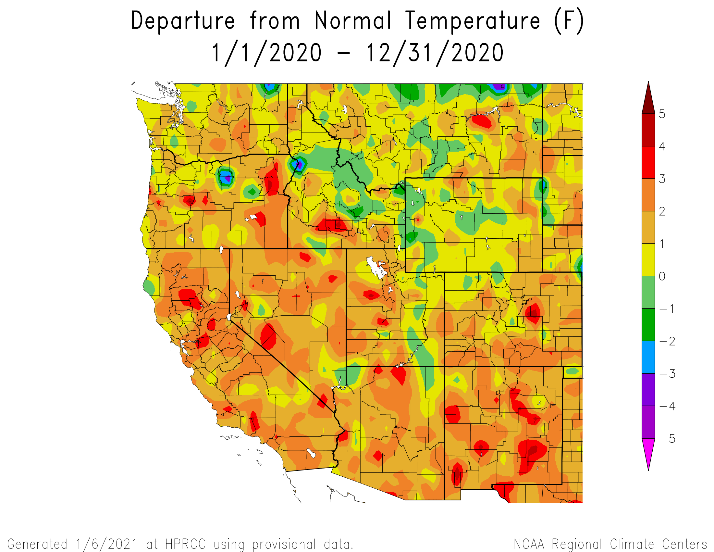
Annual temperature departures were above normal for nearly all of the Western U.S. Long-term weather stations reported record warmth in Oregon, California, and New Mexico. All western states had stations reporting in the top ten warmest years on record. No locations reported record cold or even in the bottom ten coldest years on record. Baker City, in northeast Oregon, saw its warmest year on record going back to 1944 with an annual average temperature 48.3 °F (9.1 °C), 3.9 °F (2.2 °C) above normal. Further south, Stockton, California reported its warmest year on record (in the past 72 years) at 64.8 °F (18.2 °C), 3.5 °F (1.9 °C) above normal. Oakland, California also logged its warmest year on record dating back to 1948 at 61.3 °F (16.3 °C), 3.8 °F (2.1 °C) above normal. Several other locations in central and northern California reported the second or third warmest year on record. In the Desert Southwest, Roswell, New Mexico reported its warmest year on record since records began in 1949 with an annual average temperature of 64.6 °F (18.1 °C), 3.8 °F (2.1 °C) above normal. Near-record warmth was found throughout Arizona with both Phoenix (77.2 °F [25.1 °C], 2.1 °F [1.2 °C] above normal) and Tucson (72.6 °F [22.6 °C], 3.2 °F [1.8 °C] above normal) reporting the second warmest years on record.
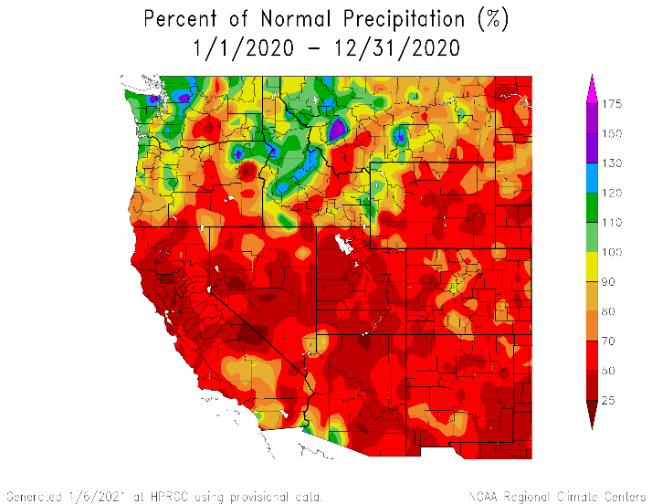
Many of the same locations that saw above normal and record high temperatures also experienced below normal precipitation and in some cases record dryness. California, Nevada, and the Four Corners states all received below normal precipitation with some pockets of above normal in Washington, Oregon, Idaho, and Montana. Baker City, Oregon logged a record low 3.36 in (85.34 mm), 33% of normal, for the year to accompany the record high temperatures. This record at Baker City is on the extreme end of the distribution and more than two inches less than the previous record of 5.63 in (143 mm) set in 2002. Record dryness (dating back to 1949) was also observed in Tucson, Arizona with 4.17 in (105.92 mm, 36% of normal) falling throughout the year. Well below normal precipitation was widespread throughout central and northern California with most stations reporting the second or third driest year on record. San Francisco, California, with one of the longest climate records in the state dating back to 1850, recorded its second driest year on record at 7.81 in (198.37 mm, 33% of normal). Further east, in California's Central Valley, Sacramento received 7.86 in (199.64 mm, 39% of normal) making it the fifth driest year since 1878. The dryness extended to the east side of the Sierra Nevada into the Great Basin; Reno, Nevada saw its second driest year since 1938 with 2.72 in (69.09 mm, 37% of normal). Areas of much above normal precipitation were far more limited relative to the extent of areas that were well below normal. One of the wetter locations was northern Washington, west of the Cascades. Bellingham, Washington recorded 41.36 in (1050.54 mm, 115% of normal) making it the sixth wettest year since 1949.
Regional snowpack, as measured by the 1 April snow water equivalent (SWE), did not stray too far from normal in 2020. Based on the 2-digit Hydrologic Unit Code watersheds, the California region had the lowest SWE at 76% of normal. The Rio Grande and Great Basin were both at 91% of normal, the Pacific Northwest and Upper Colorado both at 107% of normal, and the Lower Colorado at 108% of normal.
Despite slightly above normal snowpack in the Colorado River Basin, April-July inflows into Lake Powell were only 52% of normal due a combination of above normal temperatures and evaporative demand and a lack of any substantial early summer monsoonal rainfall. Low reservoir levels and streamflows were contributing factors to the widespread drought intensification in 2020 throughout the West. According to the U.S. Drought Monitor, 18% of the West was in drought at the beginning of the year with no locations worse than severe drought (D2). By the end of 2020, 79% of the West was in drought and 22% of the region in exceptional drought (D4). The Four Corners region began 2020 with a sizeable area of severe drought that has expanded and intensified with exceptional drought present in Nevada, Utah, Arizona, New Mexico, and Colorado by the end of 2020. California and Nevada started the year with no drought present. The dry winter and above normal temperatures throughout the year contributed to a rapid expansion of drought in these two states with only a small area in southern California remaining drought free at the end of the year. For a small area of northwest Oregon, western Washington, and northern Idaho, drought conditions improved with removal of drought for these locations.
The 2020 fire season was very active and ramped up in mid-summer and extended well into autumn. Many extremely large fires with rapid spread rates occurred this year with California, Oregon, and Colorado all having set records for the largest fires in the state's history. The California fire season started slow but then exploded due to a rare dry thunderstorm event in mid-August. During a four-day period (August 16-19) 8,532 lightning strikes were detected in central and northern California that ignited 362 new fires, including the August Complex which burned 1,032,649 acres. Colorado saw its top three largest fires in 2020 which were not fully contained until late November or early December. For the West Coast fires, the exceptionally dry winter followed by a dry and hot summer and autumn were the main climate contributing factors. The drought that was already in place combined with a failure of the monsoon and well above normal temperature were the primary climate enablers of fire in the Colorado River Basin this year.
In Alaska, annual temperatures were above normal along the North Slope, in western coastal Alaska, and the Aleutian Islands. Temperatures were below normal in the Interior, Southcentral, and Southeast regions of Alaska. Utqiagvik reported an annual temperature of 14.6 °F (-9.7 °C), 3.1 °F (1.7 °C) above normal and the 8th warmest since 1921. Nome logged its 15th warmest year on record since 1907 at 29.4 °F (-1.4 °C), 2.1 °F (1.2 °C) above normal. Precipitation for the year was above normal in the Interior and Southeast, and below normal in Southcentral and the Aleutian Islands. Cordova had its 4th driest year dating back to 1910 with 64.02 in (1626.11 mm, 71% of normal) and Kenai also saw its 4th driest year since records began in 1900 at 11.72 in (297.69 mm, 64% of normal). One of the wettest cites in Alaska, Yakutat, also had a dry year with 104.55 in (2655.57 mm, 67% of normal) making it the 6th driest on record. Meanwhile, another of the wettest cites in the state at the southern extent of Southeast Alaska, Ketchikan, logged 175.10 in (4447.54 mm, 124% of normal) making the 11th wettest year on record since 1914.
Hawaii, for the second year in a row, saw above-normal temperatures that were in some cases record-breaking. On the Big Island, Hilo recorded an annual average temperature of 76.8 °F (24.9 °C), 2.9 °F (1.7 °C) above normal and the warmest on record dating back to 1950. Five of the six warmest years on record at Hilo have occurred since 2015. Kahului, Maui also saw its warmest year on record since 1955 at 78.6 °F (25.9 °C), 2.7 °F (1.5 °C) above normal beating out the 2019 record of 78.4 °F (25.8 °C). The warmth extended northward to the island of Oahu where Honolulu recorded its 3rd warmest year on record at 78.9 °F (26.1 °C), 1.3 °F (0.8 °C) above normal. Most of the islands saw below normal precipitation with the exception of Kauai and some of southern Hawaii. The spatial extent of drought increased slightly from 18% at the beginning of the year to 19% at the end of the year. Most of the drought is focused on the central islands of Molokai, Maui, Kahoolawe, and Lanai with severe and extreme drought present.
Significant Events for 2020
January: Heavy precipitation, flooding, and landslides in the Pacific Northwest: January 2020 was the 12th wettest on record for the Northwest Climate Region and the fourth wettest on record for the state of Washington. The heavy precipitation throughout the month saturated soils causing flooding of rivers flowing out the Cascades Range in Washington as well as triggering numerous landslides that affected highway travel in western Washington and northwestern Oregon.
February: Record-breaking snowfall in central Colorado: In the Tenmile Range of central Colorado, Breckenridge and Copper Mountain ski areas both broke their February maximum snowfall records with Breckenridge logging 120 in (3048 mm) and Copper Mountain reporting 95 in (2413 mm).
March 13-18: Heavy snow in Sierra Nevada: A deep and slowly progressing cutoff low brought heavy snowfall to the northern Sierra Nevada of California and Nevada, with snowfall totals exceeding 60 inches (1500 mm) in many locations. This ideal synoptic scenario for significant snowfall accumulation more than doubled snow depths in the northern two-thirds of the range and left snow at previously barren lower elevations. However, the gains in snow water equivalent were more modest, on the order of 3-8 in. (70-200 mm). As a result, snow drought conditions remain in the range.
March 28: Extreme rainfall and flooding in Kauai: A cold core Kona low brought extreme rainfall to the leeward side of the Hawaiian island of Kauai. Many locations recorded more than 6 in. (150 mm) of rainfall in a 24-hour period, with Hanalei observing 8.33 in. (211 mm) of rainfall. The storm brought numerous flood-related impacts to the island, including high streamflows and road closures, forcing some evacuations.
April: Record-breaking seasonal snowfall accumulation in the Colorado Front Range: Boulder, Colorado recorded its snowiest winter on record (dating back to 1893) with 152 inches (3861 mm) as well as its 6th snowiest April on record with 37.3 in (947 mm).
July: Flash flooding in New Mexico: Much needed rain fell near Truth or Consequences, New Mexico, on July 27th. However, this came in a short duration with 2-3 inches falling in one hour. The city golf course, library, and police department buildings were all flooded in the event. One mobile home was reportedly lifted off of the foundation. No injuries were reported.
July: Low reservoirs in the Rio Grande Basin, New Mexico: Major reservoirs in the Rio Grande Basin are well below normal and much lower than last year due to drought, poor summer runoff, and a weak Monsoon. Elephant Butte was 14% of average (8% of capacity) compared to 45% of average (25% of capacity) last year. All seven of the reporting reservoirs in the basin were less than 64% of average at the end of July.
August: Massive wildfire outbreak in California: According to the National Interagency Coordination Center (Sept 1), a cumulative 1,370,707 acres burned in the Northern California geographic area with more than 13,000 firefighters and support personnel deployed to the region.
October: Arctic sea ice extent lowest on record: According to National Snow & Ice Data Center, the October sea ice extent ranked as the lowest (63% of average) in the satellite record. This is the largest departure from average conditions seen in any month in the satellite record at 3.69 standard deviations below the 1981-2010 mean.
December 1–2: Extreme rainfall produces mass movements in the Alaskan Panhandle: Strong and concentrated poleward atmospheric moisture transport in the form of a landfalling atmospheric river brought heavy rainfall to the Alaskan Panhandle at the start of December. Over the course of two days, the Haines Airport measured 10.26 in. (260 mm) of precipitation and Juneau Airport set a one-day precipitation record of 5.08 in. (129 mm). This storm helped Haines achieve its wettest December since records began in 1911 with a monthly total of 18.5 in. (470 mm; 300% of normal). The extreme rainfall combined with appreciable snowmelt to saturate soils and increase pore pressures. This resulted in widespread landsliding and flooding impacting 21 communities in Southeast Alaska, along with high elevation avalanches. One avalanche generated a seiche that damaged homes at Chilkat Lake. Many roads and homes were damaged or destroyed by debris flows and landslides with two people presumed dead.
2020 Departure from Normal Temperature and Percent of Normal Precipitation for Western United States