Western Regional Climate Center
March in the West
March, 2019
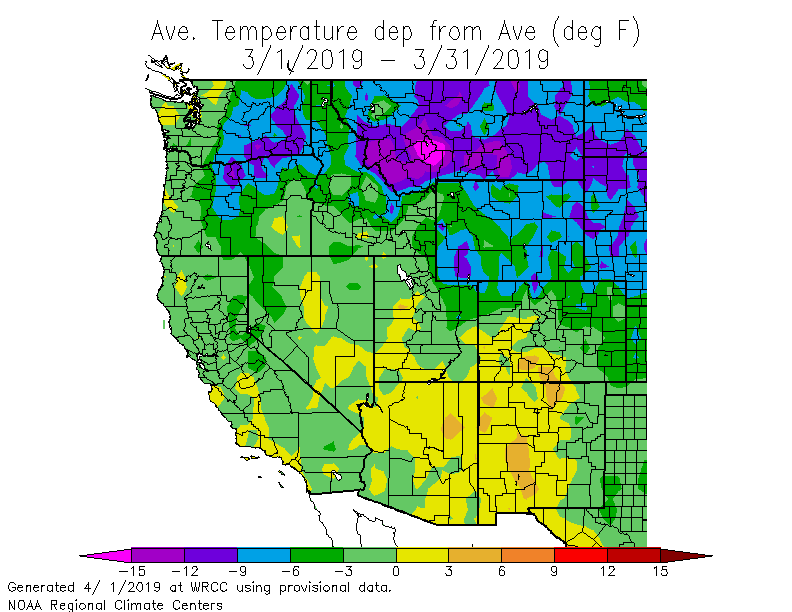
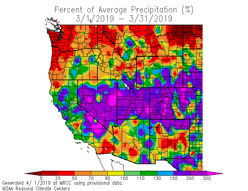
Several storms throughout March brought above normal precipitation in a broad swath extending form central California to western Colorado. Below normal precipitation persisted in the Pacific Northwest. Temperatures were below normal across the northern tier of the region, while temperatures in the southwest were slightly warmer than normal.
Below normal temperatures were observed this month in much of the West. In Montana, Bozeman reported a monthly average temperature of 17.5 °F (-8 °C), 19 °F (11 °C) below normal, and the coldest March on record since 1941. Walla Walla, WA also reported their coldest March since records began in 1949, with an average temperature of 37.8 °F (3.2 °C), 8.5 °F (5 °C) below normal. Oregon, Idaho, and Wyoming also continued to observe cold temperatures, with most locations ranging between 4-11 °F (2-6 °C) below normal. California and Nevada observed near normal to slightly below normal temperatures. In contrast to below normal temperatures in the northern part of the region, several locations in the Southwest reported above normal temperatures. Tucson, Arizona, reported an average temperature of 61.7 °F (16.5 °C), 2 °F (1 °C) above normal; while Socorro, in western New Mexico, observed an average temperature of 53.7 °F (12 °C), 4 °F (2 °C) above normal and the 9th warmest March since records began in 1893.
Precipitation was above normal in several regions throughout the Intermountain West. In eastern Nevada, Ely recorded 3.35 in (85 mm), 360% of normal and the 2nd wettest March since observations began in 1888. Nephi, Utah, recorded 3.71 in (94 mm), 227% of normal and the 3rd wettest March since records began in 1904. California also observed above normal precipitation. In the northern Central Valley, Redding recorded 9.33 in (237 mm), 213% of normal. Furnace Creek, in California’s Death Valley, recorded 1.11 in (28 mm), 370% of normal and was the 5th wettest March on record. The Southwest was generally drier than normal, with the expectation of eastern Arizona and Northern New Mexico where precipitation was 150-200% of normal. Further north, the Pacific Northwest was significantly drier than normal. Portland, Oregon, recorded 1.54 in (39 mm), 42% of normal and the 6th driest March on record. In Washington, Port Angeles observed 0.30 in (8 mm), 12% of normal and the driest March on record.
Above normal precipitation seen in the winter months continued in March for California and Intermountain West, supporting large areas of improvement in drought conditions. Only 9% of the West is experiencing moderate or worse drought conditions, compared with 26% at the end of February. Large areas of improvement were also observed in Idaho, Nevada, Arizona, New Mexico, and Utah. Oregon and Washington saw some improvement; however, much of the region remains in abnormally dry or moderate drought continues.
At the end of the March, snowpack remained above normal in most large river basins (HUC-2) of the West. The Rio Grande region observed 138% of median snow water equivalent (SWE), the Upper Colorado 134%, the Lower Colorado 173%, the Great Basin 152%, and California and the Sierra Nevada 168%. Snowpack in the Pacific Northwest and Missouri River regions was near to slightly above normal at 98% and 108% of median, respectively.
Alaska observed well-above normal temperatures statewide. In western Alaska, Bethel logged its warmest March on record with an average temperature of 30.5 °F (-3 °C), 15 °F (8 °C) above normal. Fairbanks also reported its warmest March on record since records began in 1929, with an average temperature of 27.6 °F (-2 °C), 16 °F (9 °C) above normal. One of the most impressive departures from normal was observed in Deadhorse on the North Slope, which reported an average temperature of 8 °F (-13 °C), 24 °F (13 °C) above normal and its warmest March on record. Precipitation was well below normal across South Central Alaska and above normal north of the Brooks Range. Anchorage observed 0.06 in (1.5 mm), less than 1% of normal, while Barrow reported 0.44 in (11 mm), 489% of normal. Further south, precipitation was well below normal across the state of Hawaii. Honolulu observed 0.08 in (2 mm) of precipitation and Hilo recorded 4.67 in (119 mm), 4% and 35% of normal, respectively. This was the 5th driest March at Honolulu since records began in 1940. Abnormally dry conditions expanded and/or intensified across the state. At the end of the month, 99% of the state was experiencing abnormally dry to moderate drought conditions.
Significant Events for March 2019
March (all month): Low Sea Ice Extent in the Bering Sea: By the end of March, sea ice in the Bering Sea reached a maximum extent and began rapidly retreating under anomalously warm conditions. The observed March sea ice extent is the second lowest maximum sea ice extent in the Bering Sea and the lowest March ice extent since satellite records began in 1979.
March 12: US Drought Monitor Removes All Drought Designation in California: An active storm track continued across California and the Intermountain West, further alleviating drought conditions in the region. As of March 12, the entire state of California was drought-free, according to the US Drought Monitor, for the first time in eight years.
March 22nd -31st: Harsh Winter Conditions in Montana: A harsh winter and historic spring flooding is causing significant damage to Montana's infrastructure and commerce. Spring snow melt and ice jams on major rivers have severely impacted several roads across Montana, including the closure of Interstate 90. Damage to water treatment facilities have left several Montana communities without clean drinking water for several weeks.
March 2019 Departure from Normal Temperature and Percent of Normal Precipitation for Western United States