About Us


SCENIC is a web page under development at the Western Regional Climate Center (WRCC) as part of WRCC’s contribution to the Southwest Climate Science Center (SWCSC). The purpose of SCENIC is to support the research and decision making efforts of the SW-CSC, the Landscape Conservation Cooperatives (LCC), and other stakeholders. SCENIC serves as an access point for climate data and analysis tools for the Southwest as well as the rest of the contiguous U.S.

SCENIC delivers daily data from weather stations across the U.S. from 1890- present. It also provides access to statistically downscaled climate projections (LOCA) developed at SCRIPPS and dynamically downscaled data and model outputs from NARCCAP. SCENIC also provides access to historic gridded datasets like daily, monthly, and annual data at 4 km resolution from PRISM. The complete MODIS and LANDSAT archives can be access through SCENIC via Google’s cloud computing platform Earth Engine. Users can download subsets of the data and requests can be customized by spatial and temporal extent.

Several analysis and visualization tools are available to help resource scientists in the decision-making process. Among these are tools to summarize data, identify extremes, generate custom time series graphs, and to generate climate summary tables. The Monitoring page allows users to monitor current climate and weather conditions across the U.S. The dashboard provides access to numerous climate anomaly maps, water, snow and drought information, ENSO, AO, NAO, MJO updates, and climate outlooks

DATASETS
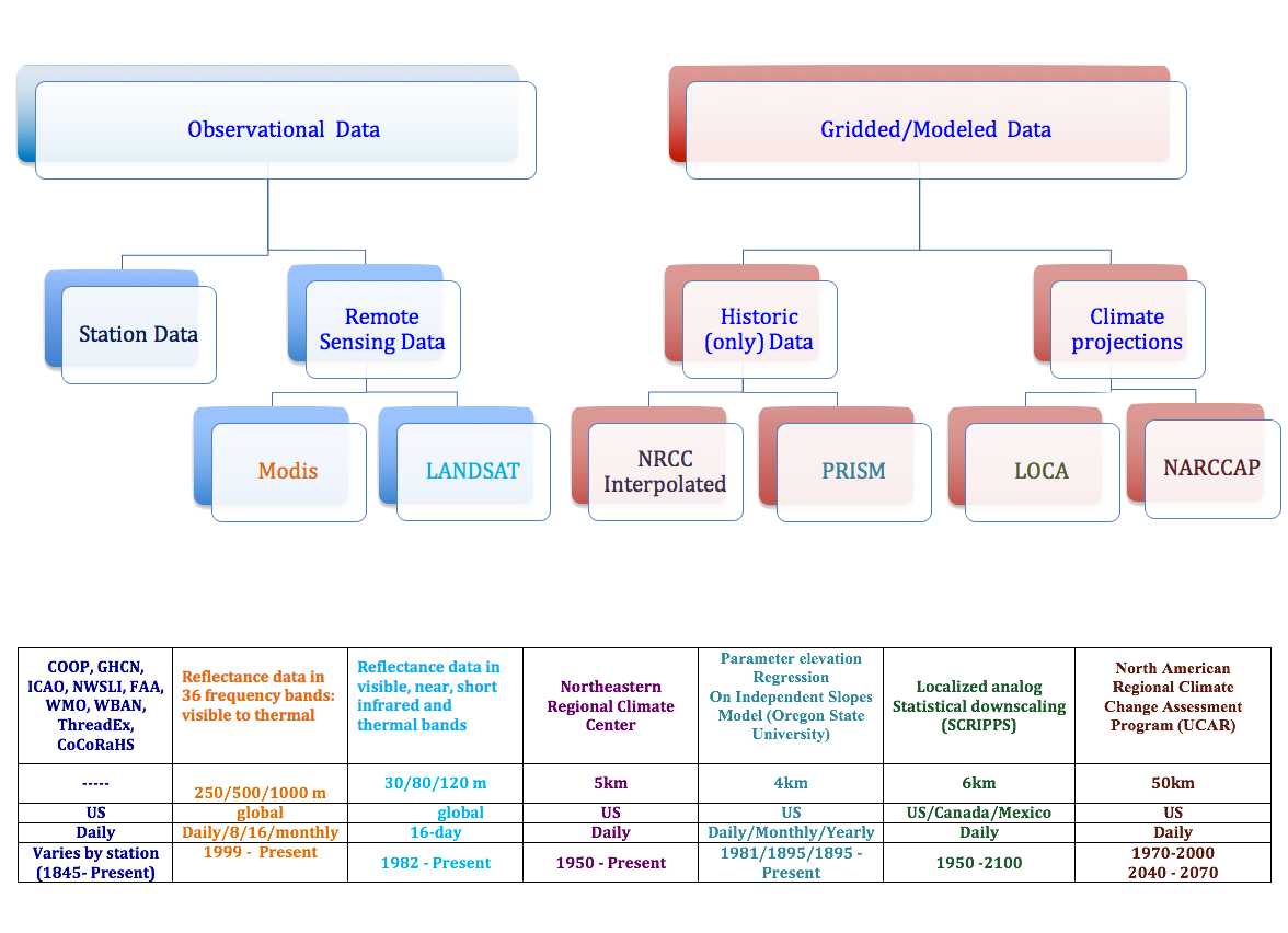
SCENIC data

How to cite the data

Remote Sensing Data (MODIS, LANDSAT)

"On-Demand Cloud Computing and Visualization of Climate and Remote Sensing Data." Climate Engine. Desert Research Institute, University of Idaho, Google,[date accessed].

All other datasets

"Applied Climate Information System." RCC-ACIS. NOAA Regional Climate Centers, [date accessed].

Analysis Tools

Single weather station or grid point

What can you find here?

Access to data and analysis tools single weather stations or grid points

Data Listers
  • Access to daily data for a weather station
  • Access to data for a grid point (daily/monthly(PRISM only)/yearly(PRISM only))
Data Analysis Tools
  • Monthly Summaries:
    Monthly Maximum, Monthly Minimum, Monthly Average, Standard Deviation,
    Number of Days (above/below/between thresholds), Range during Month, Monthly Sum
  • Yearly Summaries: Maximum, Minimum, Mean, Sum
  • Inter-year Comparison
  • General Climatology
  • Data Comparison between gridded and station data

What datasets are available?

All datassets are made available through the ACIS system.

1. Station Data

Observed Quantities
Maximum Temperature (F/C), Minimum Temperature (F/C),
Observation Time Temperature (F/C)
Snowfall (in/mm), Snow Depth (in/mm)
Derived Quantities
Average Temperature (F/C), Heating/Cooling/Growing Degree Days (F/C)

Short description of station networks

Read more about the networks

2. Gridded Data

Observed Quantities
Maximum Temperature (F/C), Minimum Temperature (F/C)
Derived Quantities
Heating/Cooling/Growing Degree Days (F/C)

Short description of grids

Multiple weather stations or grid points

What can you find here?

Access to data and analysis tools for areas

Data Listers
  • Access to data for an area of interest (daily/monthly(PRISM only)/yearly(PRISM only))
Data Analysis Tools
  • Spatial Summaries (time series over area)
        Maximum, Minimum, Mean, Sum
  • Temporal Summaries (outputs are maps)
        Maximum, Minimum, Mean, Sum
Area options
  • county, county warning area
  • climate division, drainage basin
  • custom polygon, circle or bounding box

What datasets are available?

All datassets are made available through the ACIS system.

1. Station Data

Observed Quantities
Maximum Temperature (F/C), Minimum Temperature (F/C),
Observation Time Temperature (F/C)
Snowfall (in/mm), Snow Depth (in/mm)
Derived Quantities
Average Temperature (F/C), Heating/Cooling/Growing Degree Days (F/C)

Short description of station networks

Read more about the networks

2. Gridded Data

Observed Quantities
Maximum Temperature (F/C), Minimum Temperature (F/C)
Derived Quantities
Heating/Cooling/Growing Degree Days (F/C)

Short description of grids

Publications

Establishing best practices to improve usefulness and usability
of web interfaces providing atmospheric data

Contact Us

Mail questions and comments to scenic@dri.edu

Western Regional Climate Center
2215 Raggio Parkway
Reno, NV 89512-1095
Tel: 775-674-7010
Fax: 775-674-7001
Email: wrcc@dri.edu
Open Monday - Friday
8am - 4pm Pacific Time
FB icon WRCC on Facebook